
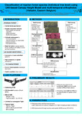
  | Michez, A., Lisein, J., Toromanoff, F., Bonnet, S., Lejeune, P., & Claessens, H. (09 September 2013). Classification of riparian forest species (individual tree level) using UAV-based Canopy Height Model and multi-temporal orthophotos (Vielsalm, Eastern Belgium) [Poster presentation]. Workshop on UAV-based Remote Sensing Methods for Monitoring Vegetation, Cologne, Germany. |
 | Bonnet, S., Toromanoff, F., Bauwens, S., Michez, A., Dedry, L., & Lejeune, P. (2013). Principes de base de la télédétection et ses potentialités comme outil de caractérisation de la ressource forestière – II. LiDAR aérien. Forêt Wallonne, (124), 28-41. |
 | Michez, A., Piégay, H., Toromanoff, F., Brogna, D., Bonnet, S., Lejeune, P., & Claessens, H. (2013). LiDAR derived ecological integrity indicators for riparian zones: Application to the Houille river in Southern Belgium/Northern France. Ecological Indicators, 34 (0), 627 - 640. doi:10.1016/j.ecolind.2013.06.024  Peer Reviewed verified by ORBi Peer Reviewed verified by ORBi |
 | Fourneau, F., Bonnet, S., Toromanoff, F., & Lejeune, P. (2012). Les outils cartographiques open source au service de la gestion des forêts et des milieux naturels. Forêt Wallonne, (118), 14-22. |
 | Bonnet, S., Toromanoff, F., Fourneau, F., & Lejeune, P. (2011). Principes de base de la télédétection et ses potentialités comme outil de caractérisation de la ressource forestière. I. Images aériennes et satellitaires. Forêt Wallonne, (114), 45-56. |