Geostationary Satellite Data; Turbidity; Reconstruction of Missing Data; Outlier Detection; DINEOF; Southern North Sea
Abstract :
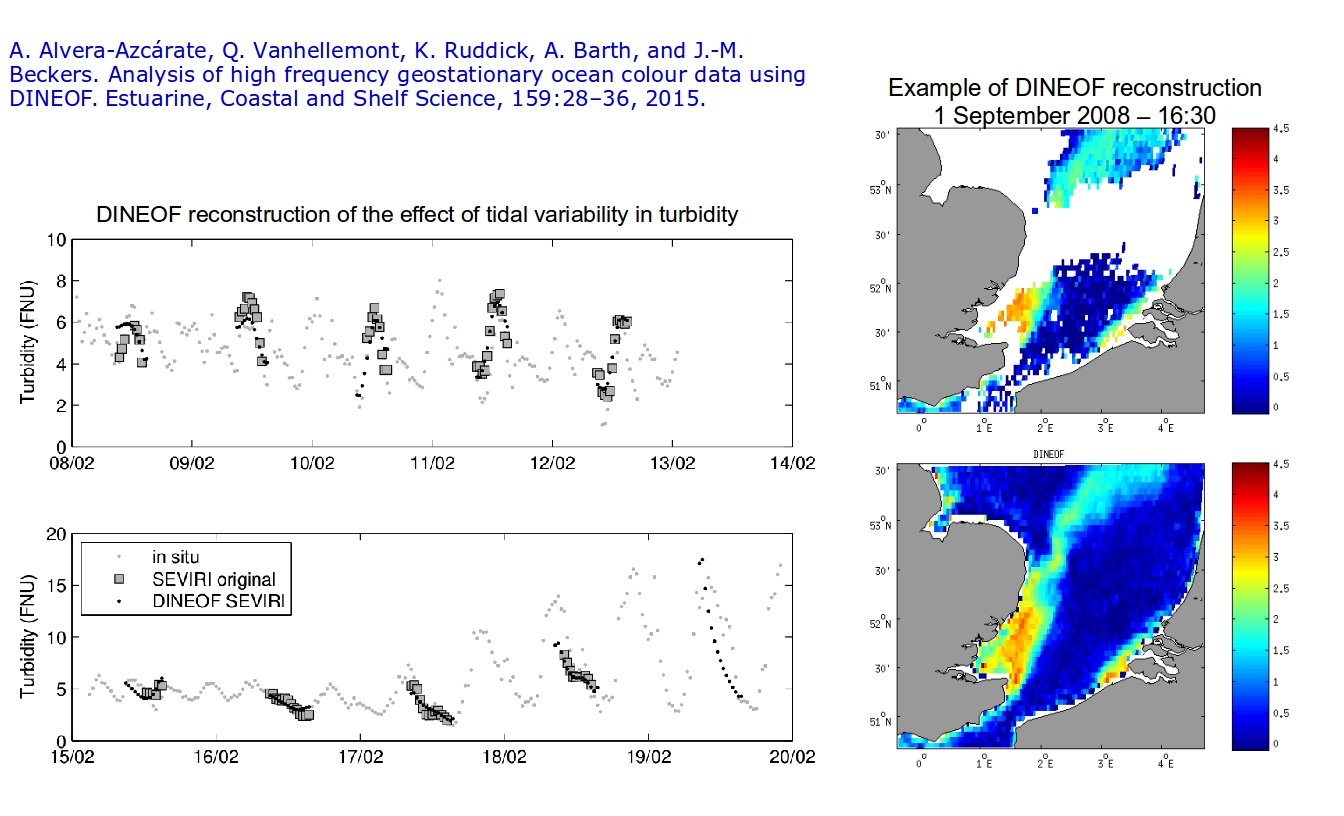
[en] DINEOF (Data Interpolating Empirical Orthogonal Functions), a technique to reconstruct missing data, is applied to turbidity data obtained through the Spinning Enhanced Visible and Infrared Imager (SEVIRI) on board Meteosat Second Generation 2. The aim of this work is to assess if the tidal variability of the southern North Sea in 2008 can be accurately reproduced in the reconstructed dataset. Such high frequency data have not previously been analysed with DINEOF and present new challenges, like a strong tidal signal and long night-time gaps. An outlier detection approach that exploits the high temporal resolution (15 min) of the SEVIRI dataset is developed. After removal of outliers, the turbidity dataset is reconstructed with DINEOF. In situ Smartbuoy data are used to assess the accuracy of the reconstruction. Then, a series of tidal cycles are examined at various positions over the southern North Sea. These examples demonstrate the capability of DINEOF to reproduce tidal variability in the reconstructed dataset, and show the high temporal and spatial variability of turbidity in the southern North Sea. An analysis of the main harmonic constituents (annual cycle, daily cycle, M2 and S2 tidal components) is performed, to assess the contribution of each of these modes to the total variability of turbidity. The variability not explained by the harmonic fit, due to the natural processes and satellite processing errors as noise, is also assessed.
Research center :
MARE - Centre Interfacultaire de Recherches en Océanologie - ULiège
Disciplines :
Earth sciences & physical geography
Author, co-author :
Alvera Azcarate, Aïda ; Université de Liège > Département d'astrophys., géophysique et océanographie (AGO) > GeoHydrodynamics and Environment Research (GHER)
Vanhellemont, Quinten
Ruddick, Kevin
Barth, Alexander ; Université de Liège > Département d'astrophys., géophysique et océanographie (AGO) > GeoHydrodynamics and Environment Research (GHER)
Beckers, Jean-Marie ; Université de Liège > Département d'astrophys., géophysique et océanographie (AGO) > GeoHydrodynamics and Environment Research (GHER)
Language :
English
Title :
Analysis of high frequency geostationary ocean colour data using DINEOF
Publication date :
2015
Journal title :
Estuarine Coastal and Shelf Science
ISSN :
0272-7714
eISSN :
1096-0015
Publisher :
Academic Press, London, United Kingdom
Volume :
159
Pages :
28-36
Peer reviewed :
Peer Reviewed verified by ORBi
Name of the research project :
Geocolour
Funders :
BELSPO - SPP Politique scientifique - Service Public Fédéral de Programmation Politique scientifique
Alvera-Azcárate, A., Barth, A., Beckers, J.-M., Weisberg, R.H., Multivariate reconstruction of missing data in sea surface temperature, chlorophyll and wind satellite fields (2007) J.Geophys. Res., 112
Alvera-Azcárate, A., Barth, A., Rixen, M., Beckers, J.-M., Reconstruction of incomplete oceanographic data sets using empirical orthogonal functions. Application to the Adriatic Sea surface temperature (2005) Ocean. Model., 9, pp. 325-346
Alvera-Azcárate, A., Barth, A., Sirjacobs, D., Beckers, J.-M., Enhancing temporal correlations in EOF expansions for the reconstruction of missing data using DINEOF (2009) Ocean Sci., 5, pp. 475-485
Alvera-Azcárate, A., Sirjacobs, D., Barth, A., Beckers, J.-M., Outlier detection in satellite data using spatial coherence (2012) Remote Sens. Environ., 119, pp. 84-91
Beckers, J.-M., Rixen, M., EOF calculations and data filling from incomplete oceanographic data sets (2003) J.Atmos. Ocean. Technol., 20 (12), pp. 1839-1856
den Eynde, D.V., Nechad, B., Fettweis, M., Francken, F., Seasonal variability of suspended particulate matter observed from SeaWiFS images near the Belgian coast (2007) Estuar. Coast. Fine Sediments Dyn., 8, pp. 291-311
Eleveld, M., van der Wal, D., van Kessel, T., Estuarine suspended particulate matter concentrations from sun-synchronous satellite remote sensing: tidal and meteorological effects and biases (2014) Remote Sens. Environ., 143, pp. 204-215
Eleveld, M.A., Pasterkamp, R., van der Woerd, H.J., Pietrzak, J.D., Remotely sensed seasonality in the spatial distribution of sea-surface suspended particulate matter in the southern North Sea (2008) Estuar. Coast. Shelf Sci., 80, pp. 103-113
Fettweis, M., Nechad, B., den Eynde, D.V., An estimate of the suspended particulate matter (SPM) transport in the southern North Sea using SeaWiFS images, in situ measurements and numerical model results (2007) Cont. Shelf Res., 27, p. 15681583
Ganzedo, U., Alvera-Azcárate, A., Esnaola, G., Ezcurra, A., Sáenz, J., Reconstruction of Sea Surface Temperature by means of DINEOF. A case study during the fishing season in the Bay of Biscay (2011) Int. J. Remote Sens., 32 (4), pp. 933-950
Greenwood, N., Parker, E.R., Fernand, L., Sivyer, D.B., Weston, K., Painting, S.J., Kröger, S., Laane, R.W.P.M., Detection of low bottom water oxygen concentrations in the North Sea, implications for monitoring and assessment of ecosystem health (2010) Biogeosciences, 7 (4), pp. 1357-1373. , http://www.biogeosciences.net/7/1357/2010/
Ocean-colour data merging (2007) Reports of the International Ocean-colour Coordinating Group. 6, , IOCCG, Dartmouth, Canada, W. Gregg (Ed.)
Li, Y., He, R., Spatial and temporal variability of SST and ocean color in the gulf of maine based on cloud-free SST and chlorophyll reconstructions in 2003-2012 (2014) Remote Sens. Environ., 144, pp. 98-108
Mauri, E., Poulain, P.M., Juznic-Zontac, Z., MODIS chlorophyll variability in the northern Adriatic Sea and relationship with forcing parameters (2007) J.Geophys. Res., 112, p. C03S11
Mauri, E., Poulain, P.M., Notarstefano, G., Spatial and temporal variability of the sea surface temperature in the Gulf of Trieste between january 2000 and december 2006 (2008) J.Geophys. Res., , (press)
Miles, T., He, R., Li, M., Characterizing the South Atlantic Bight seasonal variability and cold-water event in 2003 using a daily cloud-free SST and chlorophyll analysis (2009) Geophys. Res. Lett., 36
Mills, D., Laane, R., Rees, J., Loeff, M., Suylen, J., Pearce, D., Sivyer, D., Rawlingson, M., Smartbuoy: a marine environmental monitoring buoy with a difference (2003) Elsevier Oceanography Series, pp. 311-316. , Elsevier, H. Dahlin, N. Flemming, K. Nittis, S. Peterson (Eds.) Building the European Capacity in Operational Oceanography. Vol. 19 of Proceedings of the Third International Conference on EuroGOOS
Nechad, B., Alvera-Azcárate, A., Ruddick, K., Greenwood, N., Reconstruction of MODIS total suspended matter time series maps by DINEOF and validation with autonomous platform data (2011) Ocean. Dyn., 61 (8), pp. 1205-1214
Nechad, B., Ruddick, K.G., Neukermans, G., Calibration and validation of a generic multisensor algorithm for mapping of turbidity in coastal waters (2009) Proc. of SPIE European International Symposium on Remote Sensing, 7473, p. 74730H
Neukermans, G., Ruddick, K., Bernared, E., Ramon, D., Nechad, B., Deschamps, P.-Y., Mapping total suspended matter from geostationary satellites: a feasibility study with SEVIRI in the Southern North Sea (2009) Opt. Express, 17 (16), p. 1402914052
Neukermans, G., Ruddick, K., Greenwood, N., Diurnal variability of turbidity and light attenuation in the southern North Sea from the SEVIRI geostationary sensor (2012) Remote Sens. Environ., 124, pp. 564-580
Prandle, D., Co-tidal charts for the southern North Sea (1980) Dtsch. Hydrogr. Z., 33 (2), pp. 68-81
Ruddick, K., Neukermans, G., Vanhellemont, Q., Jolivet, D., Challenges and opportunities for geostationary ocean colour remote sensing of regional seas: a review of recent results (2014) Remote Sens. Environ., 146, pp. 63-76
Ryu, J.-H., Han, H.-J., Cho, S., Park, Y.-J., Ahn, Y.-H., Overview of geostationary ocean color imager (GOCI) and GOCI data processing system (GDPS) (2012) Ocean Sci. J., 47 (3), pp. 223-233. , http://dx.doi.org/10.1007/s12601-012-0024-4
Sirjacobs, D., Alvera-Azcárate, A., Barth, A., Lacroix, G., Park, Y., Nechad, B., Ruddick, K., Beckers, J.-M., Cloud filling of ocean color and sea surface temperature remote sensing products over the Southern North Sea by the data interpolating empirical orthogonal functions methodology (2011) J.Sea Res., 65 (1), pp. 114-130
Vanhellemont, Q., Neukermans, G., Ruddick, K., Synergy between polar-orbiting and geostationary sensors: remote sensing of the ocean at high spatial and high temporal resolution (2014) Remote Sens. Environ., 146, pp. 49-62
Volpe, G., Buongiorno Nardelli, B., Cipollini, P., Santoleri, R., Robinson, I.S., Seasonal to interannual phytoplankton response to physical processes in the Mediterranean Sea from satellite observations (2012) Remote Sens. Environ., 117, pp. 223-235