Abstract :
[en] Pollution by nitrate and pesticides has impacts on drinking water reserves and aquatic systems. Nowadays, this problem is the key point of the European Policy with the implementation of the Water Framework Directive (Directive 2000/60/EC). According to these legislations, Member States are supposed to take measures to limit environmental and toxicological effects caused by nitrate and pesticides use.
This paper presents three different approaches allowing assessment of diffuse (non-point sources) pollution risks of water resources by nitrate and pesticides. The first approach consists on the interpretation of the geomorphopedological information (geologic substratum type, presence of karst phenomena, soil texture, natural drainage, profile development, type and percent of stoniness, soil thickness, …) provided by the Digital Soil Map of Wallonia. Soil physical characteristics are assessed in terms of soil water percolation/infiltration, runoff, pollutants retention, mineralization, and erosion.
Second approach consists on the use of spatially distributed mechanistic models. Nitrate lixiviation from agricultural land to groundwater has been simulated from the SWAT model. Pesticide lixiviation from soil to groundwater has been predicted from the one-dimensional, dynamic, multi-layered model named PEARL (Pesticide Emission Assessment at Regional and Local scales). Model input parameters are mainly extracted from the existing soil physical and physico-chemical, crop and pesticides properties databases. Relevant soil parameters not directly available in existing databases, such as bulk density, hydraulic conductivity, potential evapotranspiration… have been derived from pedotransfers functions.
Third approach consists on in situ lixiviation studies by the way of lysimeters. Concentrations measured at the bottom (2 m deep) of lysimeters represent a straight “index of risk” for groundwater and, on the other hand, allow the validation of simulation models used to predict nitrate and pesticides lixiviation risk under different scenarios.
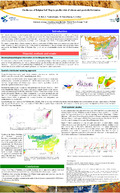
The Digital Soil Map of Wallonia, one of the core data source, allows the spatialisation of the predicted lixiviation risk at regional level, providing to the local authorities and the decision makers a tool for the identification of the areas at risk of pollution, where specific monitoring actions and prevention measures for the protection of waters can be implemented.